EMERITUS Platform Alpha version released
The identification of waste and other environmental crimes poses several challenges for Law Enforcement Authorities (LEAs), Border Guards (BGs) and other involved practitioners (e.g., environmental agencies, government agencies, police and tax authorities). Moreover, the criminal prosecution process tends to be very resource-intensive, as, among other things, there is a high standard of proof required to get a conviction. New technologies such as the use of satellites, drones, Artificial Intelligence (AI), Deep Learning (DL) and merging data gathered from various datasets can provide synoptic high-content data coverage of large areas of land or water, regularly and irrespective of inaccessibility or hazard. Such technologies can offer powerful solutions to the above issues surrounding the identification and prosecution of environmental crime.
The ambition of EMERITUS is thus to explore and demonstrate how these technologies, integrated in a single-entry point and scalable by-design platform, could improve the efficiency of environmental crime detection and intelligent risk profiling to limit the resources involved, hence, in turn, limiting the risk for operators and providing a deterrent for the offenders.
Although there are already other monitoring platforms and technology-specific solutions are at the disposal of LEAs/BGs, practitioners and decision-makers, the EMERITUS project intends to overcome the State-of-the-Art (SOA) by bringing a unique selling proposition (USP) encompassing the following aspects:
- Water contamination detection: real-time warnings about potential contamination events, along with estimated metrics including timing and severity.
- Waste storage center monitoring: using semi-automated controlled drones to estimate the volume of waste stored at a site.
- Cross-border illegal waste trafficking: detection of sites involved in waste trafficking through the analysis of optical satellite imagery and volumetric estimation using AI.
- Identification of illegal waste sites and thermal sites (fires): using detection models to find unregulated waste sites and potential occurrences of fire, which could indicate the burning of waste at a site, by analysing satellite-captured Visible Infrared Imaging Radiometer Suite (VIIRS) data.
By focusing on these areas, EMERITUS aims to not only surpass current state-of-the-art solutions but also to establish a new benchmark in the detection and prosecution of environmental crimes, providing law enforcement authorities, border guards, and other practitioners with a powerful tool to protect our planet.
To ensure widespread usability and remove language barriers, EMERITUS is designed with a multilingual user interface, coupled with a focus on ease of use to facilitate seamless adoption by users of varied technological proficiencies. This user-centric design philosophy underscores the project’s commitment to enabling practitioners across the globe to leverage the platform’s capabilities effectively.
User Interface & Experience
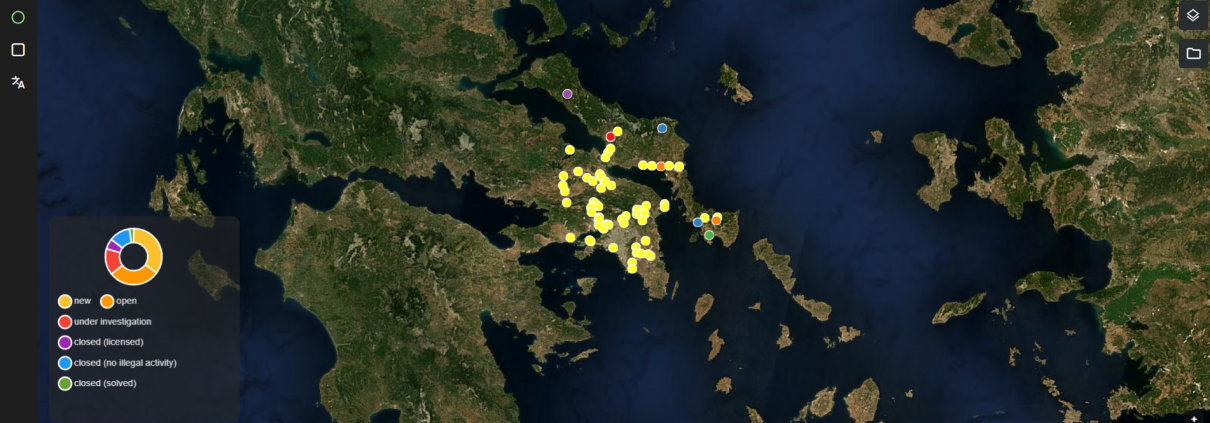
The map component is the centerpiece of the platform and the component where the users spend most of their time working with. Currently, the results from the integrated monitoring services “Waste from Space”, “Waste Traffic Detection” and “Thermal Anomaly Detection” are shown on the map. These locations are displayed by points on the map or, in case of the service “Waste Traffic Detection”, as polygons.
Moreover, the platform has a responsive design across different devices and browsers, provides an easy navigation experience through clear menus, and entails an efficient error handling and feedback component for a smooth user experience.
Users can select an area of interest to enjoy services such as
- Sensor values and predicted pollution levels;
- Remote third-party control of drone flights;
- Landfill sites monitoring for spatial extension and volumetric changes using satellite data;
- Signs of illegal waste dumping and potential fires.
What awaits in the future?
With an eye toward continuous improvement and scalability, EMERITUS is not just a static solution but a growing ecosystem. The project is on a path toward releasing a Beta version with enhanced features, laying the groundwork for the final Gamma version. This iterative development process ensures that the platform remains at the cutting edge of technology and fully responsive to the evolving needs of its users and the dynamics of environmental crimes. In the “Investigation Site details” page currently under development the tabs “Prediction Timeline”, “Files & Documents”, “Comments” and “Events” and “Expert Mode” are foreseen.
The EMERITUS platform testifies that the project’s ambition is not only to advance the state-of-the-art in environmental crime detection but also to redefine it. By bringing unique selling propositions to the table, EMERITUS stands poised to significantly improve the efficiency of LEAs and BGs, offering powerful solutions to longstanding challenges.
The EMERITUS platform is developed by GeoVille, one of the partners in project consortium and a company with more than 20 years of excellence in satellite based geo-information solutions. For further information and any questions, you can contact the consortium at info@emeritusproject.eu


